Milton, Ontario
Under the escarpment,
and growing fast.
Canada's fastest-growing municipality a decade ago, and still among its fastest today — built at the foot of the Niagara Escarpment with half the town in the Greenbelt.
A town that keeps
outgrowing its own plan.
Milton sits in the northwest corner of Halton Region, about 54 km west of Toronto along the 401. The Niagara Escarpment runs through it — the urban area at the foot, and protected Greenbelt countryside and hamlets across the northern half.
Milton — 363 km² under the escarpment
0
Residents
(2021 Census)
0 km²
Land Area
0
Incorporated
0
Median Age
On the Escarpment
Kelso, Rattlesnake Point, Crawford Lake and Mountsberg all sit in or beside the town, on a UNESCO World Biosphere Reserve.
Four 401 Interchanges
Plus Highway 407 on the eastern edge, and Milton GO reaching Union Station in about an hour on weekday rush-hour trains.
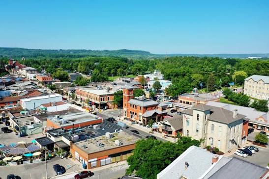
A Real Main Street
Century storefronts, restaurants, and the Milton Farmers' Market every Saturday morning from May through October.
Mill Pond
The pond that powered the original grist mill, a block off Main Street, with a 2.1 km loop trail around it.
Grown in Surveys
Because the escarpment and the Greenbelt hem it in, Milton expands in defined surveys rather than sprawling in every direction.
A University Campus
Wilfrid Laurier opened its Milton campus on Industrial Drive in September 2024, alongside two secondary schools opened in 2022.
Population, area and median age from the 2021 Census of Population (Statistics Canada). Milton grew 20.7% between 2016 and 2021, and the Town's own planning base projects roughly 400,000 residents by 2051.
What People Love
Why people move here
and then stay.
Ask ten Milton residents why they chose it and you'll get roughly these six answers.
Eighteen communities,
and what each one is like.
Milton grows survey by survey, so the year a neighbourhood was built tells you most of what you need to know. Choose one to see the schools, parks, commute and housing mix.
Historic core · Mill Pond
Where the town started
The original settlement around Sixteen Mile Creek and Mill Pond. Century homes and wartime bungalows on walkable streets, a block from Main Street.
Schools
Robert Baldwin PS, W.I. Dick PS, Bishop Reding CSS
Parks & Green Space
Mill Pond and Jaycee Trail, Victoria Park, Centennial Park
Getting Around
Walk to Main St; Hwy 25 to the 401
Walkability
Very walkable
Housing
Century homes, wartime bungalows, infill customs
Central · East of downtown
1970s streets, close to everything
Just east of the historic core, built out in the 1970s. Bungalows and back-splits on established lots within reach of Main Street.
Schools
Robert Baldwin PS, W.I. Dick PS
Parks & Green Space
Kinsmen Park, Fay Court Park
Getting Around
Milton Transit on Ontario St; five minutes to Hwy 25
Walkability
Somewhat walkable
Housing
1970s bungalows, raised bungalows, back-splits
Central-south · Mature streets
Trees, and an adult community
One of Milton's most established areas, with Centennial Forest running through it and the Drury Park adult community inside it.
Schools
Sam Sherratt PS, Milton District HS, E.C. Drury
Parks & Green Space
Centennial Forest, Sam Sherratt Park, Coulson Park
Getting Around
Close to Milton GO; Thompson Rd routes
Walkability
Somewhat walkable
Housing
Detached, links, side-splits, bungalofts
Southwest · Near the fairgrounds
Early-eighties, close to the 401
Southwest of the core beside the fairgrounds and the John Tonelli Sports Centre. Early-1980s detached and semis on settled streets.
Schools
J.M. Denyes PS, Our Lady of Victory
Parks & Green Space
Bronte Meadows Park, John Tonelli Sports Centre
Getting Around
Bronte St S to Hwy 401 in minutes
Walkability
Somewhat walkable
Housing
Early-1980s detached, semis, multi-levels
Southeast · The first new survey
Where the growth started
The first of the modern surveys, built from around 2000. Closest neighbourhood to both the GO station and the 401.
Schools
Bruce Trail PS, St. Anthony of Padua, Bishop Reding CSS
Parks & Green Space
Clarke Village Square, off-leash dog park
Getting Around
Closest survey to Milton GO and Hwy 401
Walkability
Car-dependent
Housing
2000-2013 detached, towns, condo apartments
East-central · Walk to the GO
The one you can walk to the train from
Built through the early 2000s and unusual for Milton in that much of it is within walking distance of the GO station.
Schools
Chris Hadfield PS, St. Peter, Craig Kielburger SS
Parks & Green Space
Lions Sports Park, Sprucedale Park, Knight Trail
Getting Around
Walking distance to Milton GO
Walkability
Somewhat walkable
Housing
Detached, semis, towns, live-work towns, stacked condos
East Milton · Large subdivision
Trails between the streets
A large 2000s subdivision in east Milton with the Beaty Trail running through it and quick 401 access at James Snow Parkway.
Schools
Bruce Trail PS, St. Anthony of Padua, Craig Kielburger SS
Parks & Green Space
Beaty Trail, Beaty North and South Parks, Meighen Park
Getting Around
Derry Rd bus; Hwy 401 at James Snow Pkwy
Walkability
Car-dependent
Housing
2000s detached, semis, towns, some condo apartments
South-central · French Immersion
Parks, splash pads, young families
South-central Milton along the Louis St Laurent corridor, built by Mattamy and Sundial through the late 2000s. A French Immersion hub.
Schools
Tiger Jeet Singh PS, Boyne PS, Our Lady of Fatima
Parks & Green Space
Coates Linear Park, Bristol District Park
Getting Around
Louis St Laurent transit spine; Hwy 401 via Bronte
Walkability
Car-dependent
Housing
Towns, semis, detached, condos
Southwest · Sports centre side
Beside the sports park and hospital
Southwest Milton around the Community Sports Park, close to Milton District Hospital. Built out roughly 2009 to 2015.
Schools
Anne J. MacArthur PS, Boyne PS, St. Benedict
Parks & Green Space
Milton Community Sports Park, Leiterman Park, Sunny Mount Park
Getting Around
Near the hospital; Hwy 401 via Bronte and Tremaine
Walkability
Car-dependent
Housing
Detached, semis, freehold towns
West · Escarpment views
Closest to Kelso
West Milton with escarpment views, minutes from Kelso and Glen Eden, and beside the national velodrome and Laurier's Milton campus.
Schools
Boyne PS, Lumen Christi, Milton District HS
Parks & Green Space
Speyer Park, Optimist Park, Kelso and Glen Eden nearby
Getting Around
Tremaine Rd to Hwy 401
Walkability
Car-dependent
Housing
2008-2013 detached, semis, towns
Northwest · Escarpment edge
The northwest corner
Northwest Milton below the escarpment, about ten minutes from Kelso Beach and the ski hill.
Schools
Escarpment View PS, Queen of Heaven
Parks & Green Space
Scott East and West Parks, Savoline Park
Getting Around
Bronte St N and Derry Rd; Hwy 25 north to the 401
Walkability
Car-dependent
Housing
Detached, semis, towns, some condos
South Milton · Boyne Survey
Part of the Boyne build-out
South Milton in the Boyne Survey, with new schools and a connected trail and park network going in as it completes.
Schools
Viola Desmond PS, Boyne PS, St. Scholastica
Parks & Green Space
Ford Neighbourhood Park, Bronson Park, Benjamin Chee Chee Park
Getting Around
Louis St Laurent and Fourth Line; Hwy 407 access
Walkability
Car-dependent
Housing
Newer detached, semis, towns
South Milton · Newest surveys
Still being built
One of the newest parts of town in south Milton, mostly detached and semi-detached, with parks and forest blocks built in as it goes up.
Schools
Rattlesnake Point PS, Viola Desmond PS
Parks & Green Space
Cobban Neighbourhood Park, Cobban Forest
Getting Around
Britannia Rd corridor; Hwy 407 and 401 via Tremaine
Walkability
Car-dependent
Housing
Mostly detached and semi-detached, new build
Southwest · Newest build-out
Two schools opened in 2022
Milton's southwestern edge and one of its newest surveys, with Rattlesnake Point PS and Elsie MacGill SS both opening in 2022.
Schools
Rattlesnake Point PS, Elsie MacGill SS
Parks & Green Space
New neighbourhood parks and escarpment trail links
Getting Around
Tremaine Rd and Britannia; closest to the western 401 ramps
Walkability
Car-dependent
Housing
New detached, semis, towns
South-east edge · Master-planned
The next large community
A master-planned community on the southeastern edge, with several thousand units planned across a full mix of housing types.
Schools
Craig Kielburger SS, Sainte-Anne Élémentaire
Parks & Green Space
Bowes Neighbourhood Park and a planned park network
Getting Around
Planned Britannia and Trafalgar transit; Hwy 407
Walkability
Car-dependent
Housing
New build across a full mix of housing types
West · Tremaine
Between the quarry and the escarpment
A small west-end pocket near Tremaine Road and the quarry lands, backing onto escarpment countryside.
Schools
Bussed to Milton schools
Parks & Green Space
Escarpment lands, Kelso Conservation Area nearby
Getting Around
Tremaine Rd; Hwy 401 at Tremaine
Walkability
Car-dependent
Housing
Older detached homes and larger rural lots
North rural · Guelph Line
A village on the 401
A heritage village in the rural north at Guelph Line and the 401, with Crawford Lake, Mountsberg and the radial railway museum close by.
Schools
Brookville PS, bussed to Milton secondaries
Parks & Green Space
Crawford Lake, Mountsberg Conservation Area, Halton County Radial Railway
Getting Around
No local transit; direct Hwy 401 at Guelph Line
Walkability
Car-dependent
Housing
Country estates, heritage village homes, acreages
Far north · Nassagaweya
Farmland above the escarpment
The hamlets of the former Nassagaweya Township in Milton's far north — working farms, century farmhouses and estate lots inside the Greenbelt.
Schools
Brookville PS
Parks & Green Space
Nassagaweya escarpment trails, Mountsberg Conservation Area
Getting Around
No local transit; Hwy 401 via Guelph Line or Hwy 25
Walkability
Car-dependent
Housing
Farmhouses, estate lots, rural custom homes
Neighbourhood boundaries vary between sources, and school catchments change — always confirm the catchment for a specific address with the Halton District School Board or Halton Catholic District School Board.
Fun Facts
Nine things you probably
didn't know about Milton.
A poet's name, the screw that built the Model T, and a velodrome.
Jasper Martin arrived from Northumberland around 1818 and built a grist mill on Sixteen Mile Creek. The settlement took its name from John Milton, the family's favourite author, when the post office opened in 1836.
Martin dammed the creek in the early 1820s to create the pond, which drove the grist mill for nearly a century. It's parkland now, with a 2.1 km loop around it.
Milton was named county town of the newly created County of Halton in 1853, and incorporated as a town in 1857. The first council met on July 4 that year.
P.L. Robertson moved his plant to Milton in 1908 after the town offered a $10,000 loan, roads and a rail siding. Fisher Body used more than 700 of his square-socket screws in every Model T — and Henry Ford was refused an exclusive licence.
The conservation authority bought the Kelso land in 1961 for $40,000 and built a dam because Milton flooded nearly every spring. The lake it created now supplies the snowmaking water for Glen Eden.
The name comes from the snaking glacial path of the escarpment. The cliffs hold ancient eastern white cedars and ten kilometres of trail linking to the Bruce Trail and Crawford Lake.
The Halton County Radial Railway, founded in 1953 and opened to the public in 1972, runs vintage streetcars along part of the former Toronto Suburban Railway right-of-way on Guelph Line.
The Mattamy National Cycling Centre opened in January 2015 for the Pan Am Games. Its 250-metre timber track with 42-degree banking was the first UCI Class 1 indoor velodrome in Canada.
Chris Hadfield graduated from Milton District High School in 1977. A Milton public school, a park, a street and an air cadet squadron are all named after him.
Sources include the Milton Historical Society, the Town of Milton, Conservation Halton, the Canadian Encyclopedia and Statistics Canada.
Homes in Hamilton
See what's on the market
right now.
Every active listing across Hamilton, updated as it comes to market. Lower city or Mountain is the first question — and it's worth talking through before you search.